JOHN SPEED MAP C1627 INVASIONS ENGLAND & IRELAND Engraved ARMADA Civil Wars

Item History & Price
| Reference Number: Avaluer:7841 | Cartographer/Publisher: John Speed |
| Date Range: 1600-1699 | Original/Reproduction: Antique Original |
| Era: 1600s |
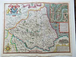
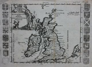
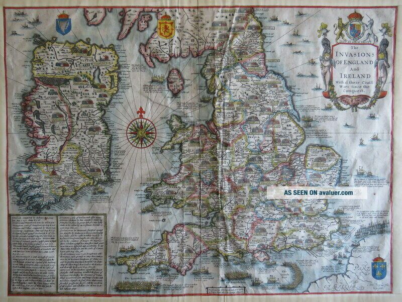
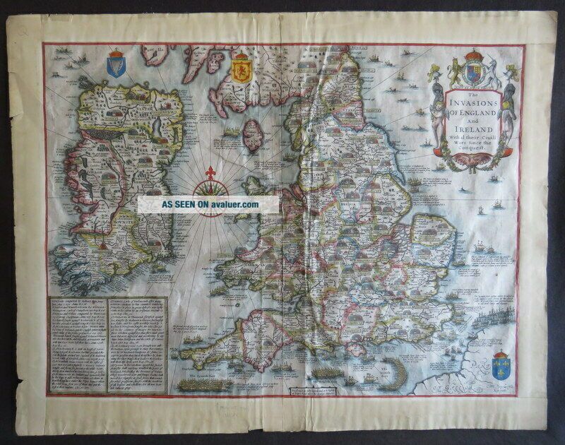
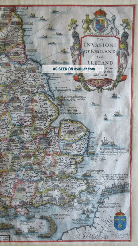
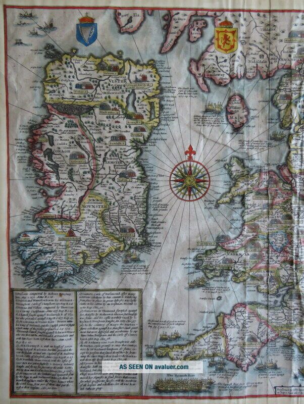
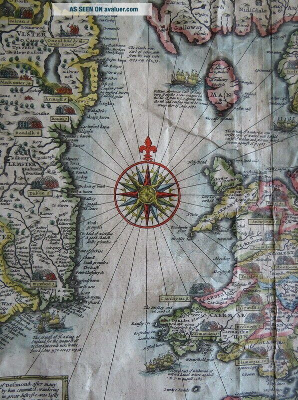
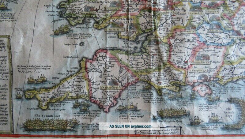
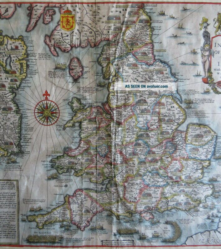
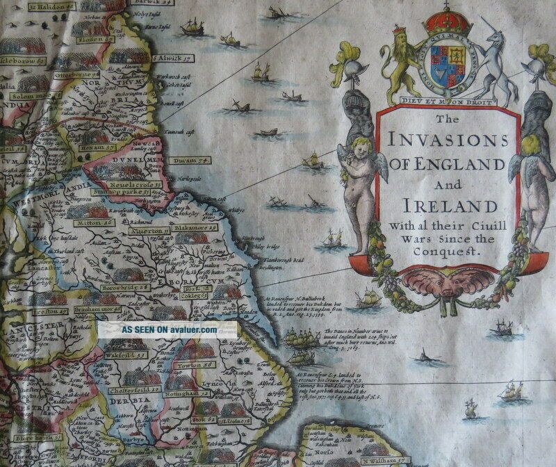
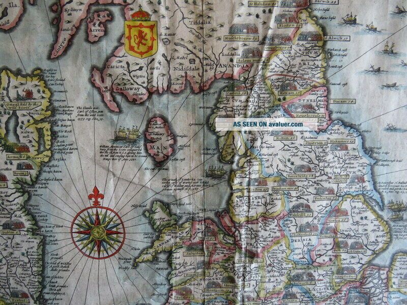
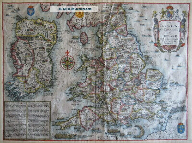
'The INVASIONS OF ENGLAND and IRELAND With al their Civill Wars Since the Conquest'
by John Speed
[George Humble, 1627, or later]
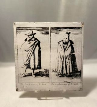
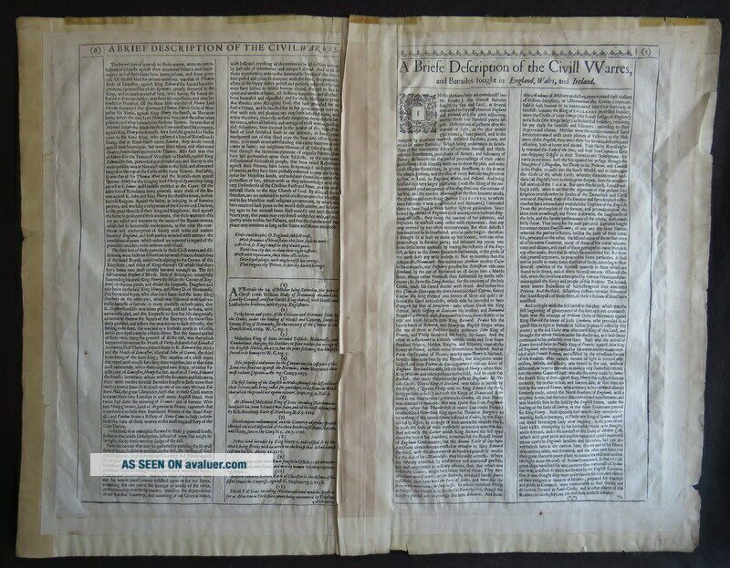
A striking decorative 17th century map of England & Wales and Ireland. Displaying all the major battles and invasions from the Norman Conquest to the Spanish Armada. The land battles are marked by opposing phalanxes of troops, the invasion places from Sea by attacking fleets. With coloured cartouche and compass rose. A...ll the main settlements are marked, along with county boundaries. Engraved by Dutchman Cornelis Dancers, whose signature appears in the lower right corner. Two blocks of text to the lower left hand side of the map are devoted to Irish history. Sea battles are also described including the relatively recent defeat of the Spanish Armada whose progress, pursued by the English fleet, is clearly illustrated and recorded in panels of text, along the Channel and into the North Sea. The reverse of the map has English text describing the wars.
John Speed (1552-1629) was the most famous cartographer of his age. His 'Theatre of Great Britain' was the first atlas of the British Isles: Speed prepared the maps himself about two years before they were published. His maps and books dominated the seventeenth-century English market. The present map is most likely taken from the 1627 English edition published by George Humble.
Copper engraved, the image measures 55.5cm x 37.5cm, with hand colouring. As can be seen from the images, the margins have been trimmed and re-margined. The newer edges are a little worn, nicked, torn. These margins are browned and a little grubby, with some pencil to bottom. The fold is a bit worn. The verso has some remnants of fixing tape to the top edges. The image is a little creased in places, although the hand colouring remains nice and crisp and bright.
English Text to verso, with woodcut first letter.
An attractive, original, John Speed, hand coloured, copper engraved map, depicting the invasions of Britain and Ireland.
Terms & Conditions
*Payment Details: We accept Paypal, UK Cheques, Postal Orders, *Shipping: We will gladly ship anywhere in the World, and combine multiple items to reduce postal costs. *Packaging: All our books, will be carefully and securely packaged. We aim to send all items within 48 hours of payment. *Returns Policy: If you are unhappy in any way, for whatever reason, with the transaction or the item, please contact us as soon as possible. Your item is fully refundable without question. *Our Policy: We aim to give detailed and accurate descriptions, and have established a reputation for honesty, quality and reliability, which we hope to continue. We know that sometimes ebay or internet buying can be a bit daunting, so please feel free to ask any questions, ask for more details or images, and we will be happy to help. We are very approachable and want to make this a pleasant experience. TRADE WITH CONFIDENCE
by John Speed
[George Humble, 1627, or later]
A striking decorative 17th century map of England & Wales and Ireland. Displaying all the major battles and invasions from the Norman Conquest to the Spanish Armada. The land battles are marked by opposing phalanxes of troops, the invasion places from Sea by attacking fleets. With coloured cartouche and compass rose. A...ll the main settlements are marked, along with county boundaries. Engraved by Dutchman Cornelis Dancers, whose signature appears in the lower right corner. Two blocks of text to the lower left hand side of the map are devoted to Irish history. Sea battles are also described including the relatively recent defeat of the Spanish Armada whose progress, pursued by the English fleet, is clearly illustrated and recorded in panels of text, along the Channel and into the North Sea. The reverse of the map has English text describing the wars.
John Speed (1552-1629) was the most famous cartographer of his age. His 'Theatre of Great Britain' was the first atlas of the British Isles: Speed prepared the maps himself about two years before they were published. His maps and books dominated the seventeenth-century English market. The present map is most likely taken from the 1627 English edition published by George Humble.
Copper engraved, the image measures 55.5cm x 37.5cm, with hand colouring. As can be seen from the images, the margins have been trimmed and re-margined. The newer edges are a little worn, nicked, torn. These margins are browned and a little grubby, with some pencil to bottom. The fold is a bit worn. The verso has some remnants of fixing tape to the top edges. The image is a little creased in places, although the hand colouring remains nice and crisp and bright.
English Text to verso, with woodcut first letter.
An attractive, original, John Speed, hand coloured, copper engraved map, depicting the invasions of Britain and Ireland.
Terms & Conditions
*Payment Details: We accept Paypal, UK Cheques, Postal Orders, *Shipping: We will gladly ship anywhere in the World, and combine multiple items to reduce postal costs. *Packaging: All our books, will be carefully and securely packaged. We aim to send all items within 48 hours of payment. *Returns Policy: If you are unhappy in any way, for whatever reason, with the transaction or the item, please contact us as soon as possible. Your item is fully refundable without question. *Our Policy: We aim to give detailed and accurate descriptions, and have established a reputation for honesty, quality and reliability, which we hope to continue. We know that sometimes ebay or internet buying can be a bit daunting, so please feel free to ask any questions, ask for more details or images, and we will be happy to help. We are very approachable and want to make this a pleasant experience. TRADE WITH CONFIDENCE