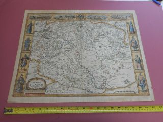
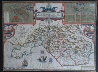
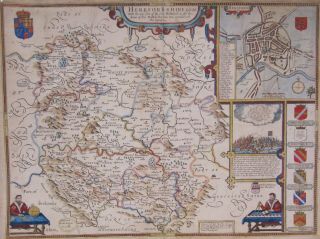
SPEED MAP C1676 WALES Counties COLOUR ENGRAVED Basset & Chiswell
Item History & Price
| Reference Number: Avaluer:7833 | Cartographer/Publisher: John Speed |
| Date Range: 1600-1699 | Year: 1676 |
| Country/Region: Wales |
Original Hand coloured SPEED map
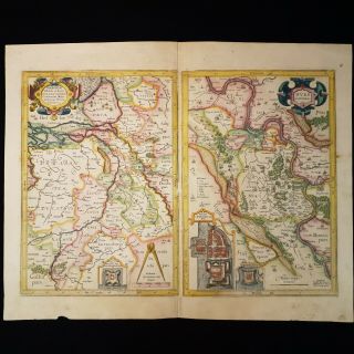
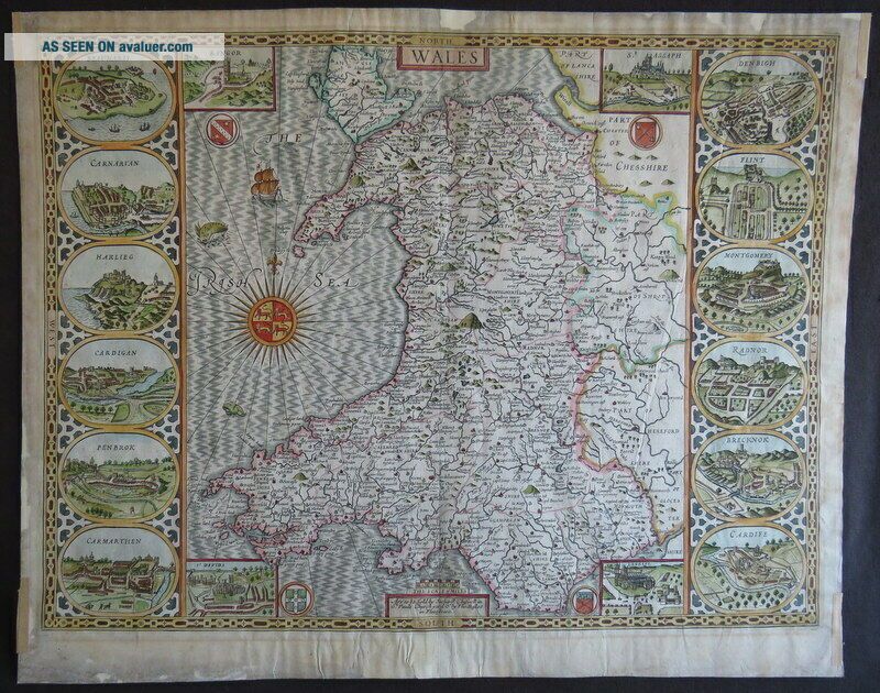
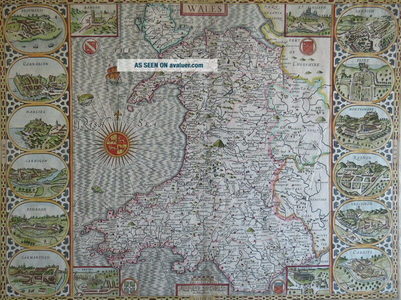
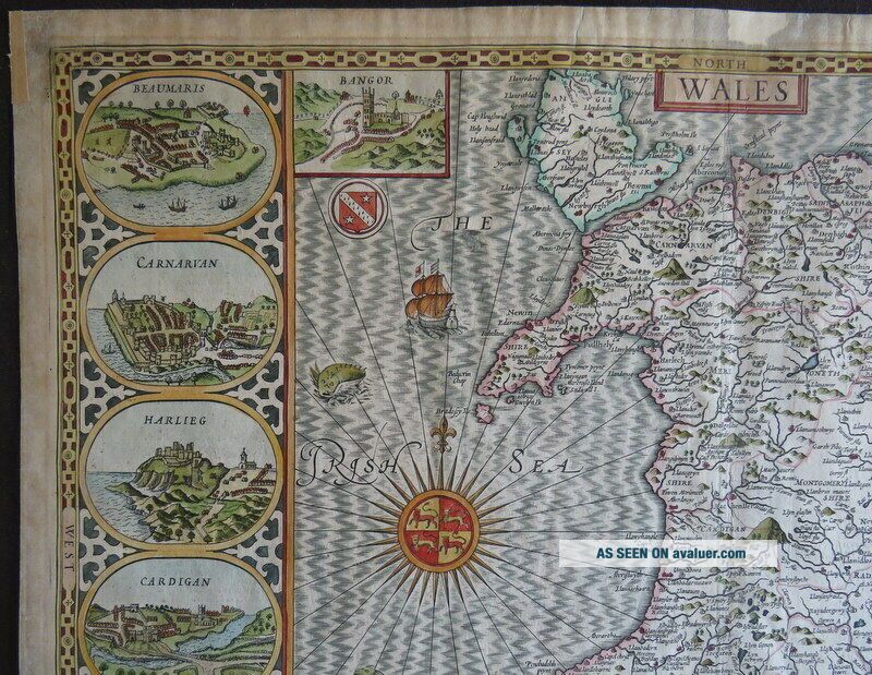
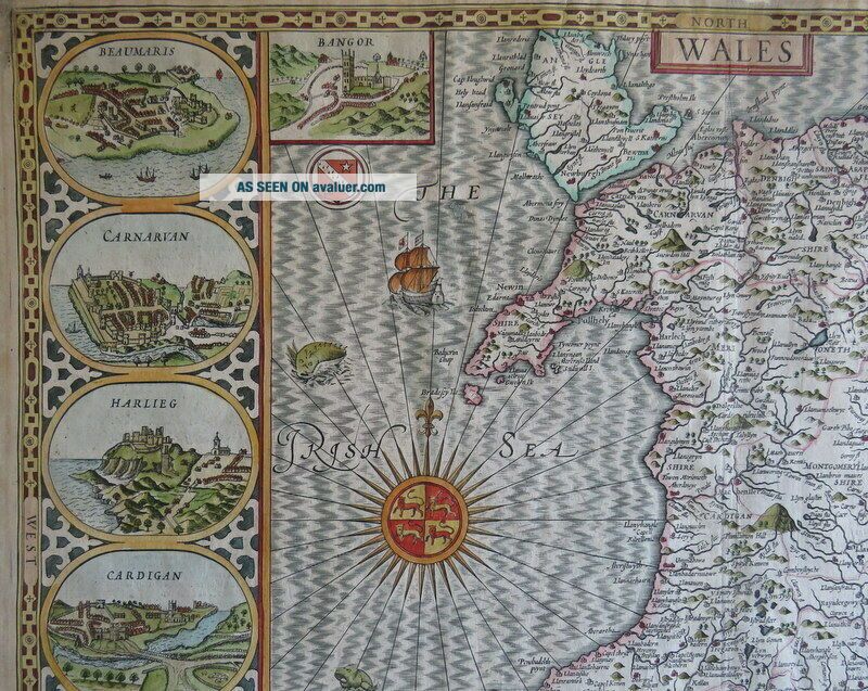
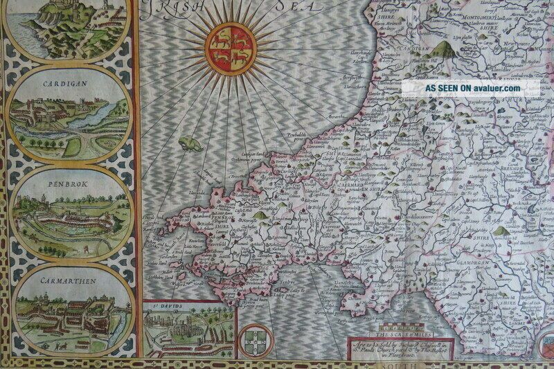
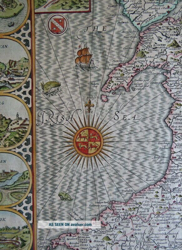
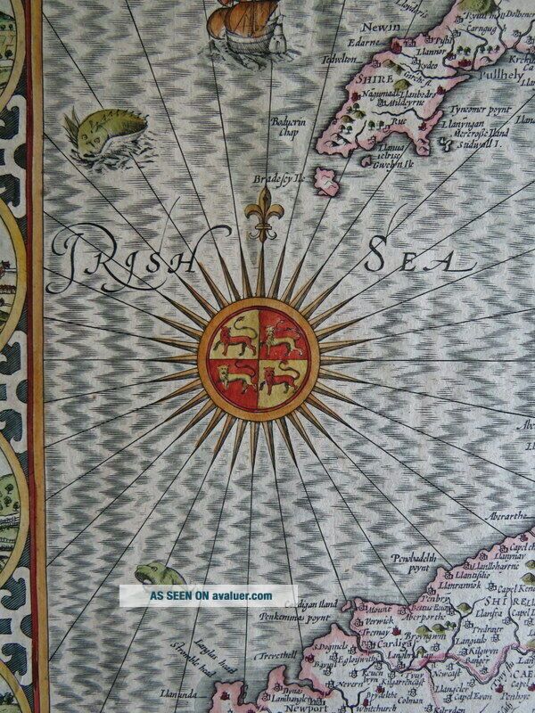
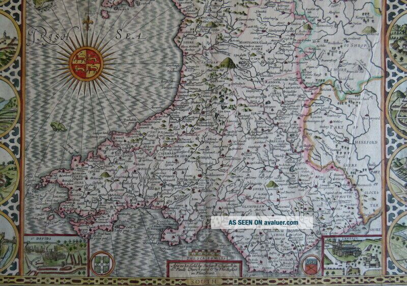
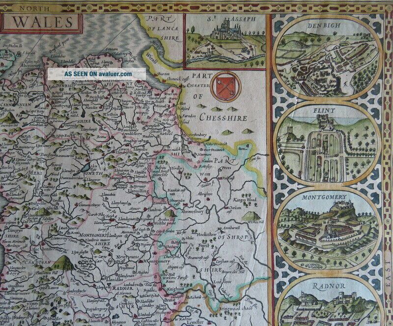
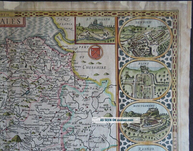
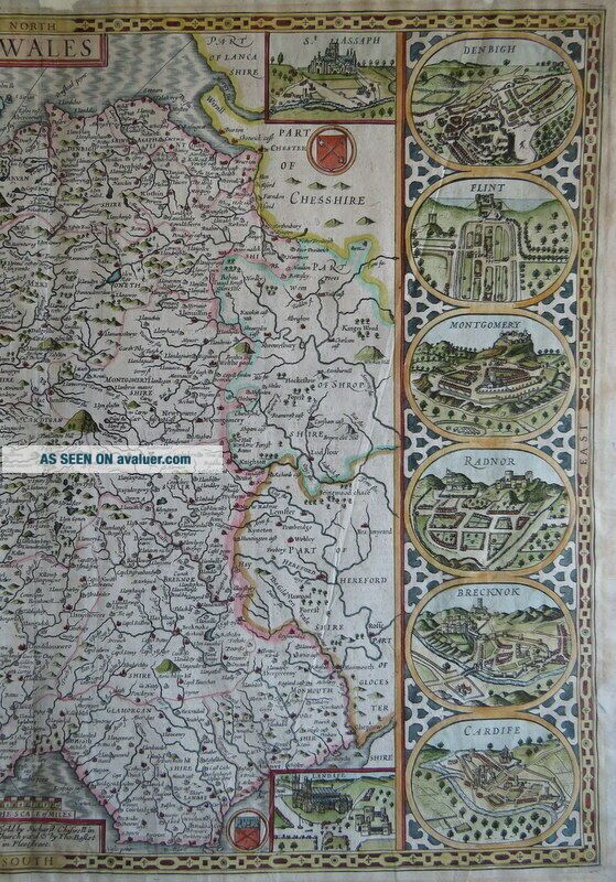
'WALES' Publisher's imprint of Basset and Chiswell, whose edition of Speed's atlas was issued in 1676
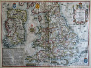
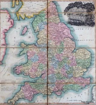
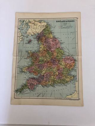
Showing Welsh counties and parts of adjoining English counties, including much of Herefordshire, Cheshire and Shropshire.Showing towns, some villages, churches, rivers, hills and mountains.Lovely compass rose in Irish Sea bearing the Arms of the Princes of Wales at its centre.Twelve charming views of the County Towns of Wales are displa...yed to vertical edges, with smaller insets of the four Cathedral Cities of Bangor, St Asaph, Llandaff and St. David's to each corner.Ship and a sea creatures.
John Speed's famous maps of the English and Welsh counties were first published in 1611 in The Theatre of the Empire of Great Britaine, designed as a companion volume to Speed's History of Great Britaine.
John Speed (1552-1629) was the most famous cartographer of his age. His maps and books dominated the seventeenth-century English market.
Copper engraved, measuring 54cm x 42.5cm, with hand colouring. As can be seen from the images, the margins are grubby and are nicked and chipped with crude repairs (see photos), touching image to top. Couple of repaired tears (one slightly larger). Wrinkled/creased. There are several tiny holes/nicks. Pale grubbiness.
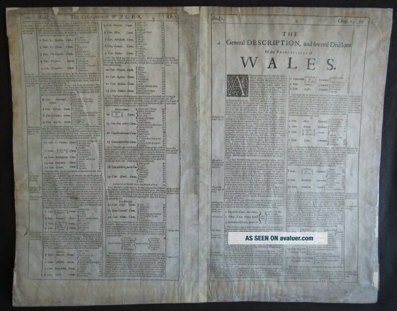
The reverse of the map has English text, with woodcut first letter, and there is a central fold.
An attractive, original, John Speed, hand coloured, copper engraved map.
Terms & Conditions
*Payment Details: We accept Paypal, UK Cheques, Postal Orders, *Shipping: We will gladly ship anywhere in the World, and combine multiple items to reduce postal costs. *Packaging: All our books, will be carefully and securely packaged. We aim to send all items within 48 hours of payment. *Returns Policy: If you are unhappy in any way, for whatever reason, with the transaction or the item, please contact us as soon as possible. Your item is fully refundable without question. *Our Policy: We aim to give detailed and accurate descriptions, and have established a reputation for honesty, quality and reliability, which we hope to continue. We know that sometimes ebay or internet buying can be a bit daunting, so please feel free to ask any questions, ask for more details or images, and we will be happy to help. We are very approachable and want to make this a pleasant experience. TRADE WITH CONFIDENCE
'WALES' Publisher's imprint of Basset and Chiswell, whose edition of Speed's atlas was issued in 1676
Showing Welsh counties and parts of adjoining English counties, including much of Herefordshire, Cheshire and Shropshire.Showing towns, some villages, churches, rivers, hills and mountains.Lovely compass rose in Irish Sea bearing the Arms of the Princes of Wales at its centre.Twelve charming views of the County Towns of Wales are displa...yed to vertical edges, with smaller insets of the four Cathedral Cities of Bangor, St Asaph, Llandaff and St. David's to each corner.Ship and a sea creatures.
John Speed's famous maps of the English and Welsh counties were first published in 1611 in The Theatre of the Empire of Great Britaine, designed as a companion volume to Speed's History of Great Britaine.
John Speed (1552-1629) was the most famous cartographer of his age. His maps and books dominated the seventeenth-century English market.
Copper engraved, measuring 54cm x 42.5cm, with hand colouring. As can be seen from the images, the margins are grubby and are nicked and chipped with crude repairs (see photos), touching image to top. Couple of repaired tears (one slightly larger). Wrinkled/creased. There are several tiny holes/nicks. Pale grubbiness.
The reverse of the map has English text, with woodcut first letter, and there is a central fold.
An attractive, original, John Speed, hand coloured, copper engraved map.
Terms & Conditions
*Payment Details: We accept Paypal, UK Cheques, Postal Orders, *Shipping: We will gladly ship anywhere in the World, and combine multiple items to reduce postal costs. *Packaging: All our books, will be carefully and securely packaged. We aim to send all items within 48 hours of payment. *Returns Policy: If you are unhappy in any way, for whatever reason, with the transaction or the item, please contact us as soon as possible. Your item is fully refundable without question. *Our Policy: We aim to give detailed and accurate descriptions, and have established a reputation for honesty, quality and reliability, which we hope to continue. We know that sometimes ebay or internet buying can be a bit daunting, so please feel free to ask any questions, ask for more details or images, and we will be happy to help. We are very approachable and want to make this a pleasant experience. TRADE WITH CONFIDENCE