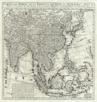
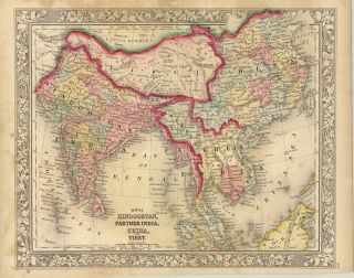
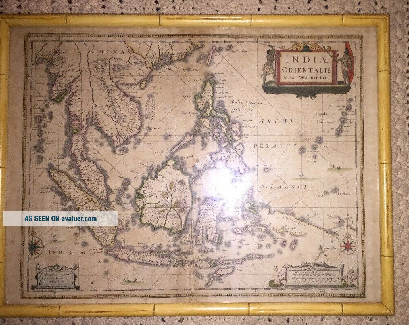
1639 Map Of SE Asia, India, Australia By Johannes Janssonius Rare
Item History & Price
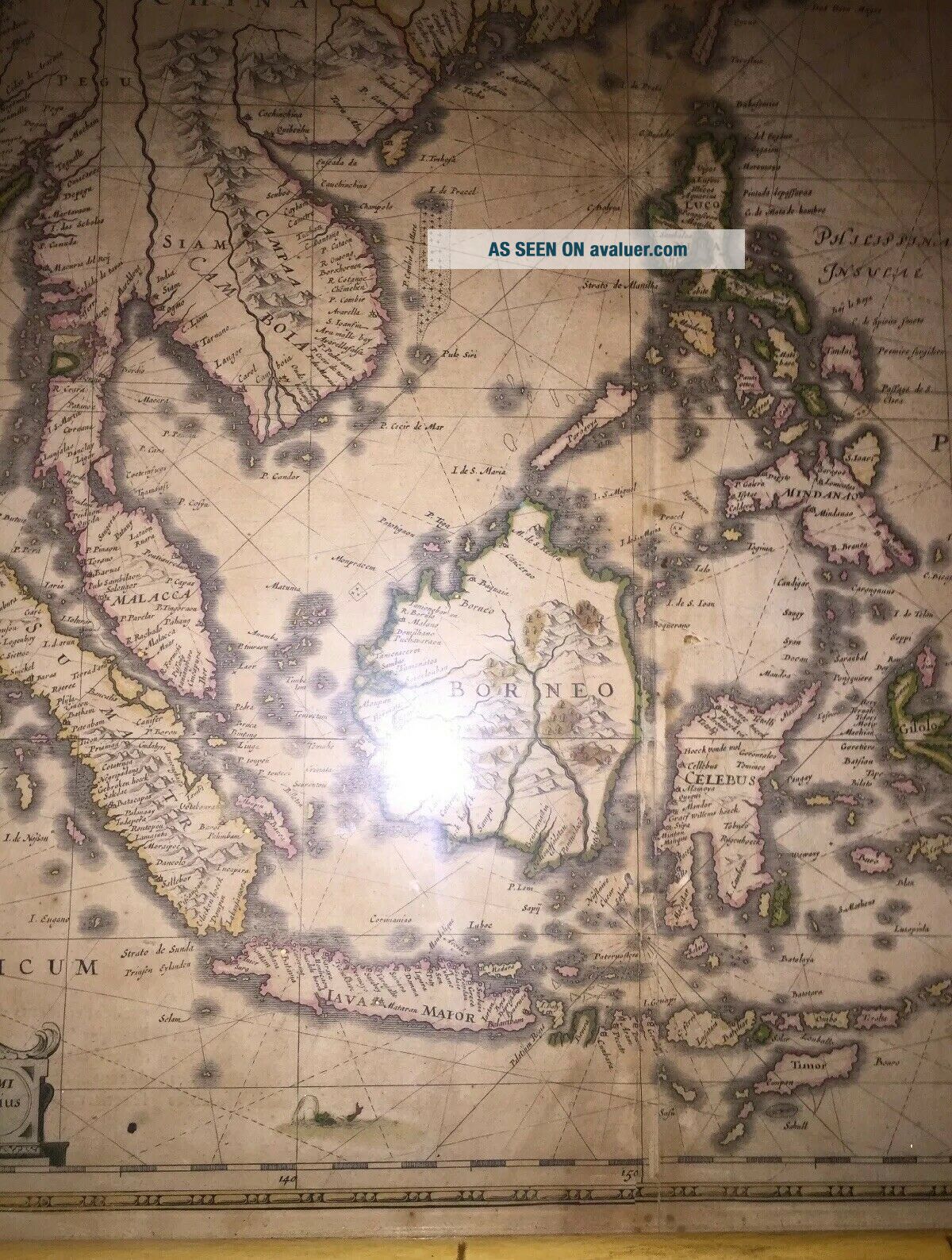
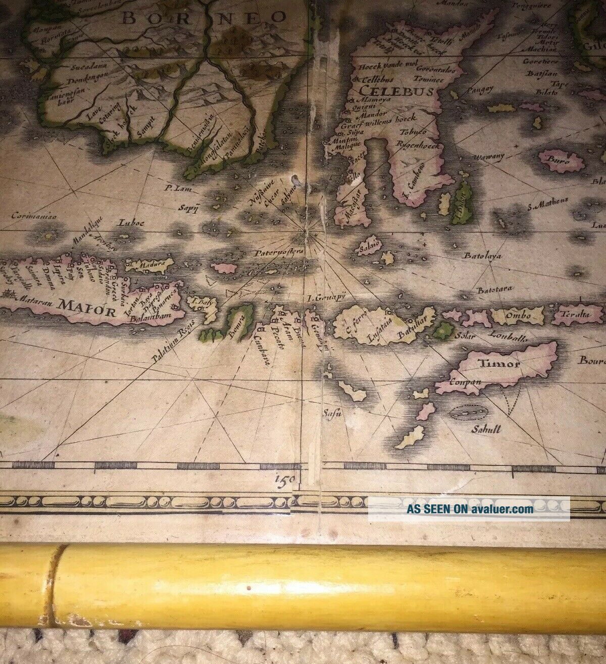
Up for consideration is an Indiae Orientalis Nova Descriptio - Original Map of Southeast Asia Date of this edition: 1639Cartographer : - Jan (Janssonius) Jansson 1588-1664Size: - 22 1/2in x 19in (570mm x 485mm)Condition: - (B) In Excellent ConditionPlease examine the picture carefully. It constitutes a good part of the description.
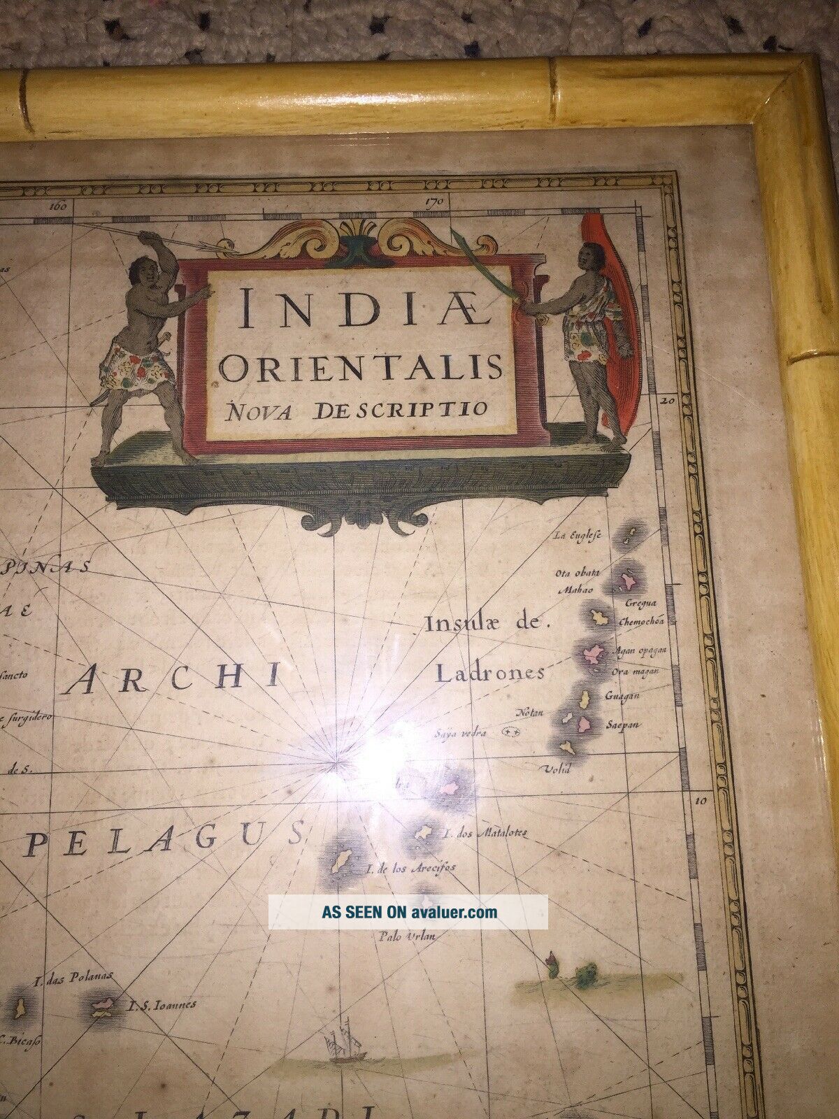
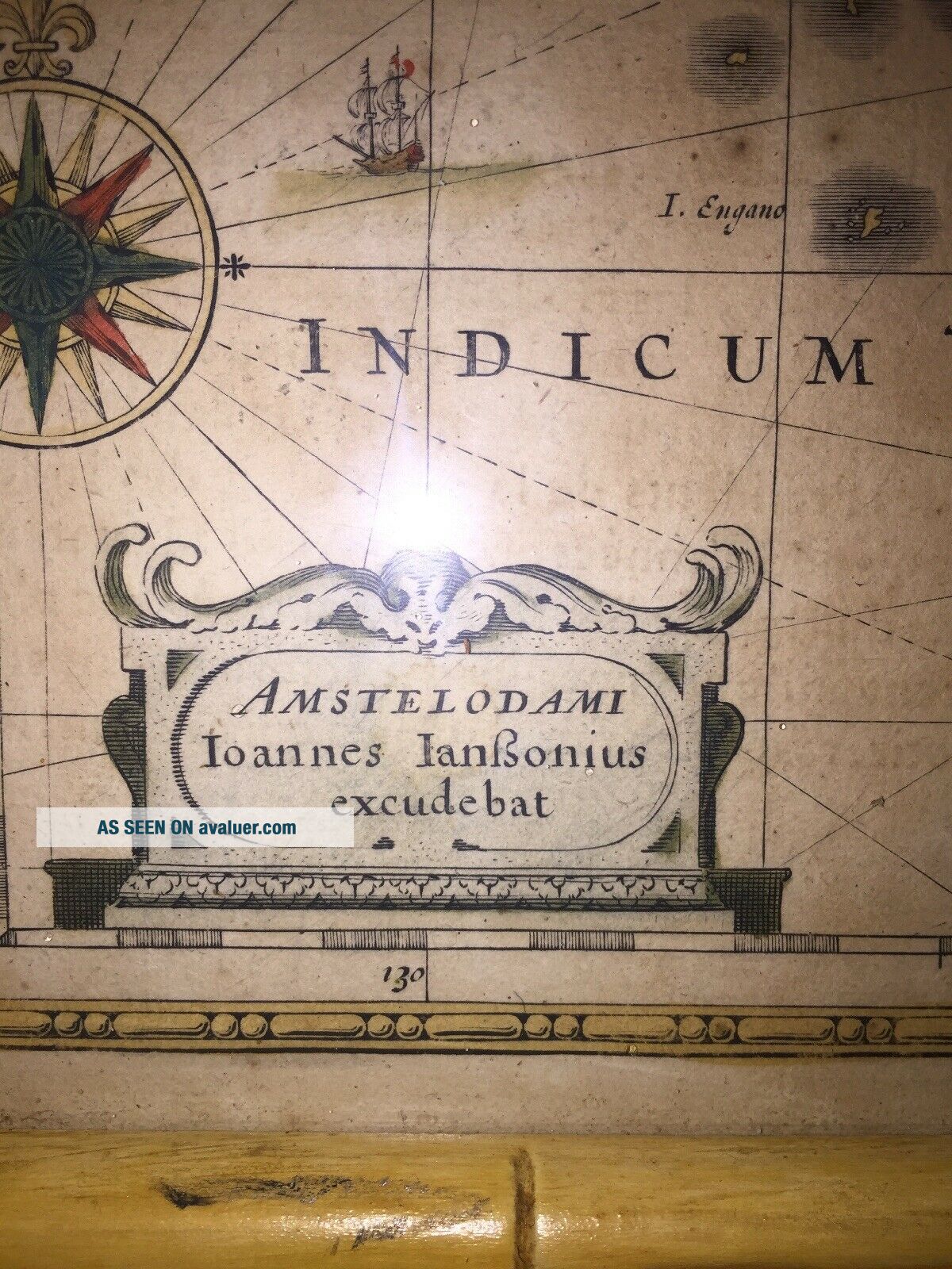
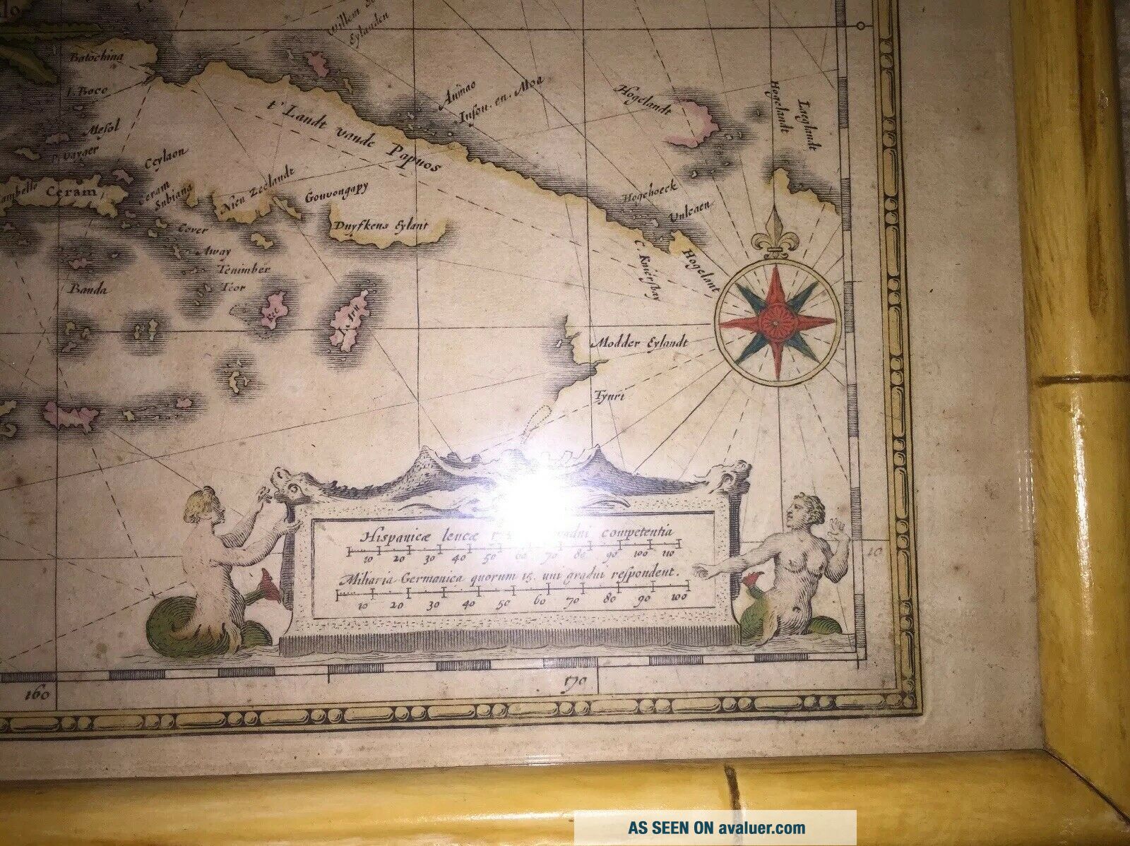
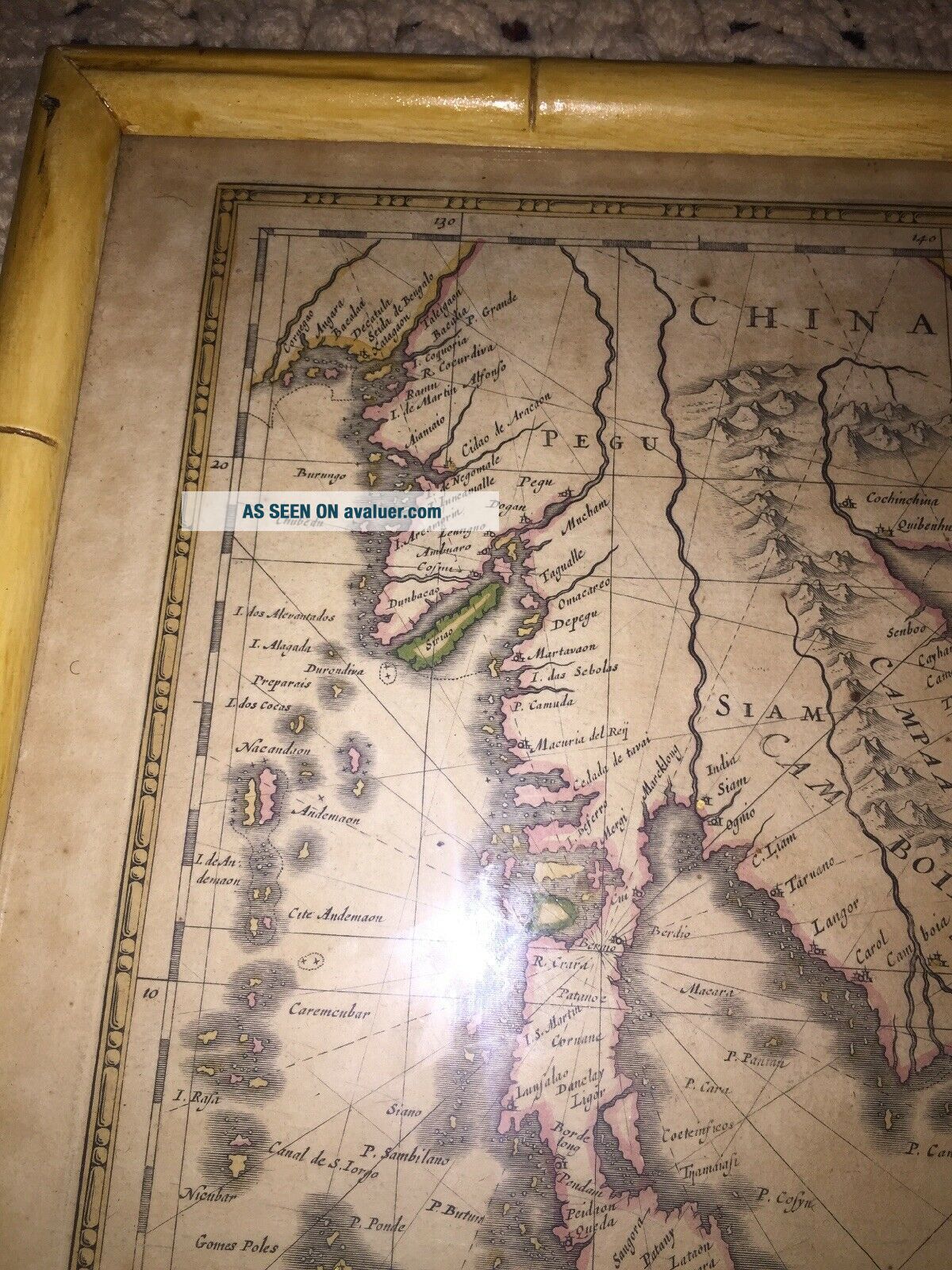
Description: This beautiful, very significant original antique map of SE Asia, the East Indies and significantly a small portion of the west coast of Aus...tralia's Cape York Peninsular was published in the 1639 French edition of Mercator's Atlas published by Henricus Hondius and Jan Jansson.General Definitions:Paper thickness and quality: - Heavy and stablePaper color : - off whiteAge of map color: - OriginalColors used: - Yellow, green, blue, pinkGeneral color appearance: - AuthenticPaper size: - 22 1/2in x 19in (570mm x 485mm)Plate size: - 20in x 15 1/2in (510mm x 395mm)Margins: - Min 1in (25mm)Imperfections:Margins: - Uniform age toning, bottom centerfold restoredPlate area: - Uniform age toning, centerfold re-joinedVerso: - German You can see from front that there is german writing on back of map.Janssonius was born in Arnhem, the son of Jan Janszoon the Elder, [1] a publisher and bookseller. In 1612 he married Elisabeth de Hondt, the daughter of Jodocus Hondius. He produced his first maps in 1616 of France and Italy. In 1623 Janssonius owned a bookstore in Frankfurt am Main, later also in Danzig, Stockholm, Copenhagen, Berlin, Königsberg, Geneva and Lyon. Elisabeth Hondius died in 1627 and he remarried Elisabeth Carlier in 1629. In the 1630s he formed a partnership with his brother in law Henricus Hondius, and together they published atlases as Mercator/Hondius/Janssonius.Under the leadership of Janssonius the Hondius Atlas was steadily enlarged. Renamed Atlas Novus, it had three volumes in 1638, one fully dedicated to Italy. In 1646, a fourth volume came out with "English County Maps", a year after a similar issue by Joan Blaeu. Janssonius' maps are similar to those of Blaeu, and he is often accused of copying from his rival, but many of his maps predate those of Blaeu and/or covered different regions. By 1660, at which point the atlas bore the appropriate name "Atlas Major", there were 11 volumes, containing the work of about a hundred credited authors and engravers. It included a description of "most of the cities of the world" (Townatlas), of the waterworld (Atlas Maritimus in 33 maps), and of the Ancient World (60 maps). The eleventh volume was the Atlas of the Heavens by Andreas Cellarius. Editions were printed in Dutch, Latin, French, and a few times in German.After Janssonius's death, the publishing company was continued by his son-in law, Johannes van Waesbergen. The London bookseller Moses Pitt attempted publication of the Atlas Major in English, but ran out of resources after the fourth volume in 1683.Background: This landmark map is the first published record of the discoveries made by the Dutch ship Dufken on route to Cape York in Australia. New Guinea ("Landt vande Papuos") is marked the (Is)land next to it is called Ô Nieu Zeelandt Õ and the island Duyfkens is named after the ship Duyfken.With the first publication of this map 27 years had passed since the voyage of the Dufken and its discoveries of PNG and NW Australia had been completed. The Dutch East India Company had suppressed the discoveries until it was sure how profitable or not Australia would be.Jansson & Hondius were the first to published this map in 1630 and it is believed the information was leaked from the Blaeu firm - the official cartographers to the Dutch East India Company. Surprisingly Blaeu did not publish a similar map for another two years. It must have been incredibly galling for Blaeu to have known of the discoveries for nearly thirty years and then to have been beaten to publication by his fiercest rival Jansson & Hondius. Given this information this is an incredibly significant map of this imporatant region being the first map published with concrete first hand knowledge of the area which prior had been mapped based mainly on speculation or second hand knowledge.The text running for two pages on the back of the map generally describes the region or country name, history (as it was), temperature, seasons, soil and agricultural productivity. Also described is the topography, wildlife, local inhabitants their culture and religion, as well as a description of major European and local towns and cities. This text makes extremely enjoyable reading and a very good insight not only into the area described but the general European attitudes towards alien countries and cultures. (Ref: Suraz; Koeman; M&B; Tooley)Jan (Janssonius) Jansson 1588-1664Johannes Janssonius, more commonly known to us as Jan Jansson, was born in Arnhem where his father was a bookseller and publisher (Jan Janszoon the Elder). In 1612 he married the daughter of the cartographer and publisher Jodocus Hondius, and then set up in business in Amsterdam as a book publisher. In 1616 he published his first maps of France and Italy and from then onwards he produced a very large number of maps, perhaps not quite rivaling those of the Blaeu family but running a very close second in quantity and quality. From about 1630 to 1638 he was in partnership with his brother-in-law, Henricus Hondius, issuing further editions of the Mercator/Hondius atlases to which his name was added. On the death of Henricus he took over the business, expanding the atlas still further, until eventually he published an 11-volume Atlas Major on a scale similar to Blaeu's Atlas Major.The first full edition of Jansson's English County Maps was published in 1646 but some years earlier he issued a number of British maps in the Mercator/Hondius/Jansson series of atlases (1636-44); the maps were printed from newly engraved plates and are different from the later 1646 issue and are now rarely seen (see Appendix B for further details). In general appearance Jansson's maps are very similar to those of Blaeu and, in fact, were often copied from them, but they tend to be more flamboyant and decorative.After Jansson's death his heirs published a number of maps in an Atlas Contractus in 1666, later still many of the plates of his British maps were acquired by Pieter Schenk and Gerard Valck who published them again in 1683 as separate mapsPLEASE READ BEFORE BIDDING:
Please read the entire auction listing, including shipping costs, before writing to ask a question.
OUR GOAL IS CUSTOMER SATISFACTION. In order to meet that goal, we will ALWAYS work with our customers on any concerns that may arise. Because of that dedication, there should be no need to open a resolution dispute before working with us. Please keep in mind, we would prefer to continue to provide you the opportunity to acquire the rare music we present each and every week.
Payment is required within seven days. We mail all paid items ONE WEEK after auctions end. Our listings are time consuming in detail and we are often traveling to find these gems, which at times delays the delivery schedule by a day or two. We ALWAYS process and ship every paid order. We have no control over parcels once they are mailed from our local Post Office. Overseas mail to some countries (Italy, Russia, France, in particular) has become very slow. Opening a dispute for slow mail is unacceptable. We work hard to provide excellent service. We take Customer Service seriously, and want you to be satisfied. Please give us 5 stars in each category through the feedback system, and we will be able to effectively continue to fulfill your passion for rare and collectible music! We have served thousands of satisfied customers - far more than our feedback records indicate - and our aim is to continue to do so.
Thank you for your interest and support.
~~~~~~~~~~~~~~~~~~~~~~~~~~~~~~~~~~~~~~~~~~~~~~~~~~~~~~~~~~
SHIPPING:
USA ~ 1 LP = $4.00 Media
Priority rates vary by area; please inquire.
All Canadian and Overseas shipping ~ Please inquire about rates. Priority shipping rates required on any order $200+ ~ Also, in the best interest of all of us, safe Express shipping rates on any order totaling $400+Note to International buyers: If you are unable to bid on our auctions, send us an e-mail and we will try to fix your problem.
WE DO NOT USE EBAY's GLOBAL SHIPPING PROGRAM. Be certain that your Customs forms are processed by us and your package will be postmarked and mailed at our local Post Office.
Discount shipping on multiple LPs in same order.
Shipped with USPS Priority Mail.