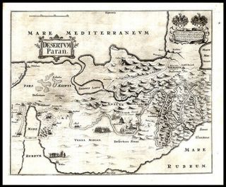
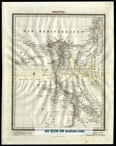
1831 Middle East Estruc Map Of Egypt Hand Colored Copper Plate Engraving


Item History & Price

Information:
Reference Number: Avaluer:180358Date of Publication: 1831
Subject: Geography, Maps, Middle EastBinding: Loose Pages
Original/Facsimile: Copper Plate Engraving Hand-ColoredRegion: Europe
Language: SpanishAuthor: Domingo Estruc, Pablo Alabern and Ramon Alabern
Place of Publication: Spain
Original Description:

Click on the image
for a detailed view. Date: 1831Short Title: EgyptFull Title: Egipto. Domingo Estruc lo grabo 1831. Source: Coleccion De Mapas Geograficos, Antiguos Y Modernos Del Acreditado Tardieu Y Otros Autores Clasicos, Publicada Por Los Redactores Del Diccionario Geografico Universal En El Ano 1835. Barcelona, En La Libreria de Jose Torner, calle del Pegomi num. 4, Donde tambien se hassa el Diccionario. This collection of maps published in 1835 was created by Dom...ingo Estruc, Pablo Alabern and Ramon Alabern (son of Pablo) for Barcelona Publisher, Jose Torner’s, Diccionario Geografico Universal (1830-1834). Ramon Alabern is often credited with creating the first Spanish Daguerreotype on 10 November, 1839. Estruc is famous for his very rare and highly detailed 1835 map of Cuba requiring 18 separate steel plates with an overall measurement of 12ft. by 5ft.Size of Map: 34.5cm X 41.5cm (13 1/2” X 16 1/2”)Description: Hand coloured country and regional borders. Presents Egypt, “Siria”- modern Israel, Lebanon and Syria, “Arabia”- modern Jordan and Saudi Arabia with names of cities, mountain ranges, bodies of water (including the Mediterranean Sea and “Bahr Kolzum O Mar Rojo” – modern Red Sea) and geographic relief. Spanish, French, Egyptian, German and English distance scales at bottom outside of border. Prime Meridian is Madrid. Fine condition with Fine plate marking. References: Tooley’s A-D, 15; Q-Z , 284; Phillips, Vol. IV, 4318 (26);A Great Gift For Any Manuscript Collector We Now Accept PayPal! We Ship Worldwide. Please Contact Us For a Free Shipping Quote!
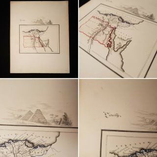


    Similar items


  • A Pictorial Map Of Egypt By Tourist Administration (1960) [19x21]

    A Pictorial Map Of Egypt By Tourist Administration (1960) [19x21]

  • 1650 Thomas Fuller Map Palestine Middle East The Wandering Of The Jews

    1650 Thomas Fuller Map Palestine Middle East The Wandering Of The Jews

  • 17th Century Map Of The Middle East

    17th Century Map Of The Middle East

  • Egyptian Papyrus,  Tourist Map Of Egypt 20x15 Cm Hand Painted

    Egyptian Papyrus, Tourist Map Of Egypt 20x15 Cm Hand Painted

  • Undated Hand Drawn & Coloured Map Of Egypt Arabia Arcadia Pyramids Manuscript

    Undated Hand Drawn & Coloured Map Of Egypt Arabia Arcadia Pyramids Manuscript

  • Antique Map Of Persia (modern Iran) And Middle East

    Antique Map Of Persia (modern Iran) And Middle East

  • 1872 Labberton Map - Assyrian Empire Iraq Syria Egypt Mossul Nineveh Middle East

    1872 Labberton Map - Assyrian Empire Iraq Syria Egypt Mossul Nineveh Middle East

  • Middle East,  Teiran,  Block Of 4  Two With A Silver Border

    Middle East, Teiran, Block Of 4 Two With A Silver Border


    • You might also like


    • Lovely Florals & Butterfly 1776 Buchoz Hand - Colored Engraving Medicinal Botany

      Lovely Florals & Butterfly 1776 Buchoz Hand - Colored Engraving Medicinal Botany

    • Rubricated Incunable Leaf Folio Thomas Aquinas (28) - 1490

      Rubricated Incunable Leaf Folio Thomas Aquinas (28) - 1490

    • Rubricated Incunable Leaf Folio Thomas Aquinas (27) - 1490

      Rubricated Incunable Leaf Folio Thomas Aquinas (27) - 1490

    • 1523 Post Incunable Vitruvius Archiecture With 170 Woodcuts - Rare

      1523 Post Incunable Vitruvius Archiecture With 170 Woodcuts - Rare

    • 1657 Polyglot Bible Syriac Greek Latin

      1657 Polyglot Bible Syriac Greek Latin

    • 1786 Comte De Buffon Hand - Colored Engraving Ring Sparrow & The Grivelin Birds

      1786 Comte De Buffon Hand - Colored Engraving Ring Sparrow & The Grivelin Birds

    • 1713 Maria Sibylla Merian Prints Hand - Colored Engraving Carnation & Moths

      1713 Maria Sibylla Merian Prints Hand - Colored Engraving Carnation & Moths

    • Engraved Map Of China Tibet Gobi Desert 1749 Jacques Nicolas Bellin Geography

      Engraved Map Of China Tibet Gobi Desert 1749 Jacques Nicolas Bellin Geography

Avaluer          About Us          Privacy Policy          Contact Us          UP
© 2022, avaluer.net, Inc. or its affiliates