1868 US Coast Survey Map Nantucket Arc Long Island Sound


Item History & Price

Information:
Reference Number: Avaluer:58938120Cartographer/Publisher: Benjamin Peirce
Year: 1868Printing Technique: Lithography
US State: Connecticut, Massachusetts, New Hampshire, New York, Rhode IslandOriginal/Reproduction: Antique Original
City: Long IslandFormat: Folding Map
Date Range: 1800-1899Type: Nautical Map
Country/Region: United States of America
Original Description:
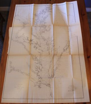
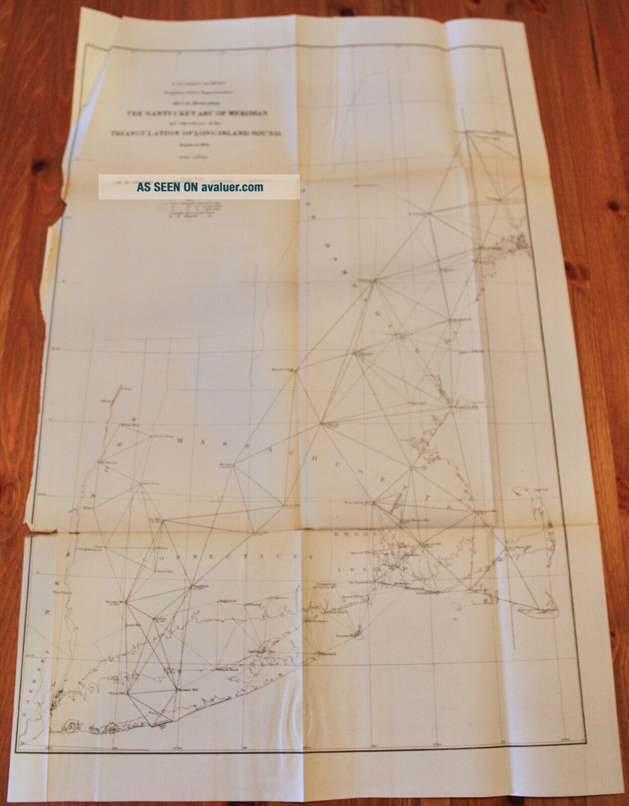
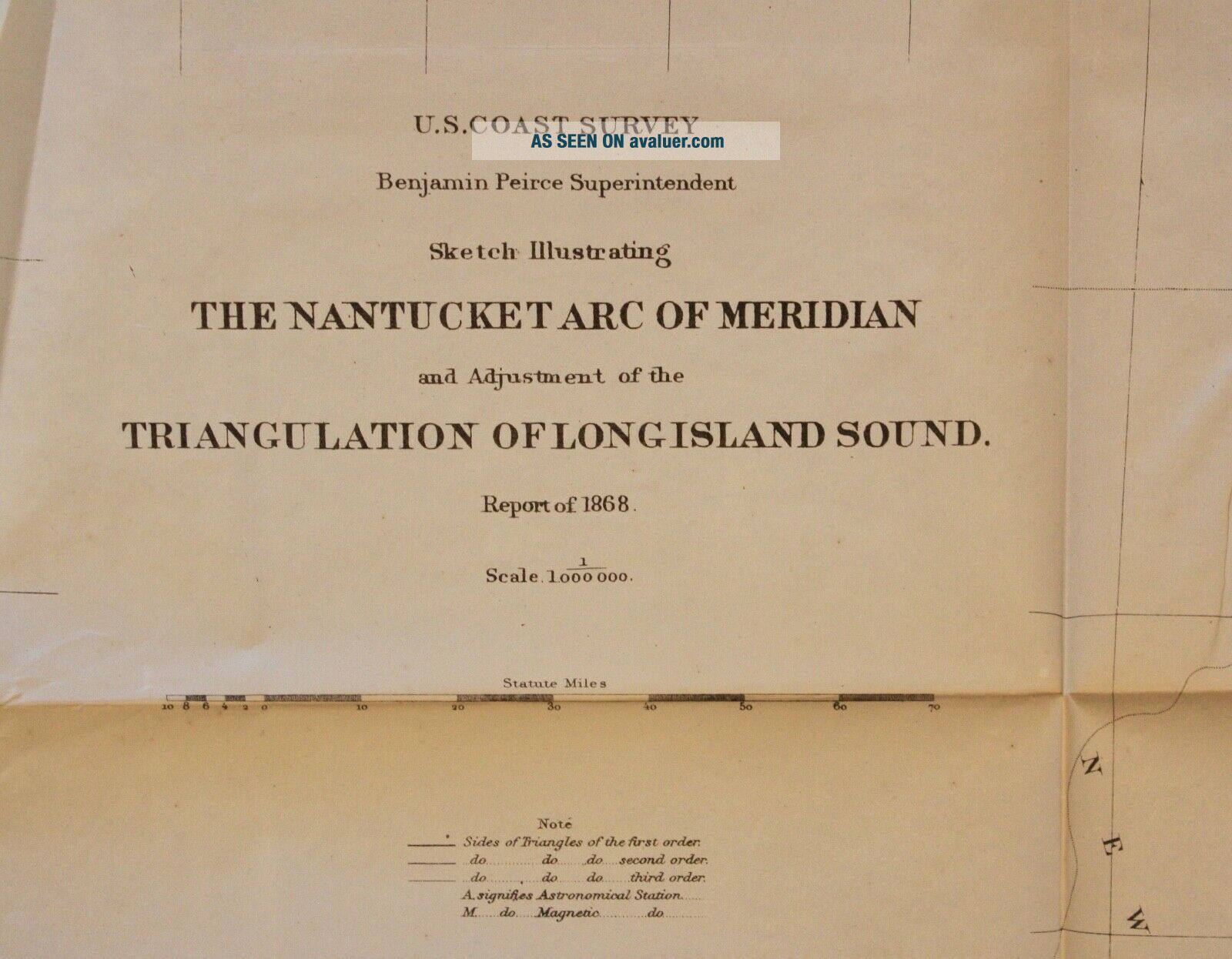
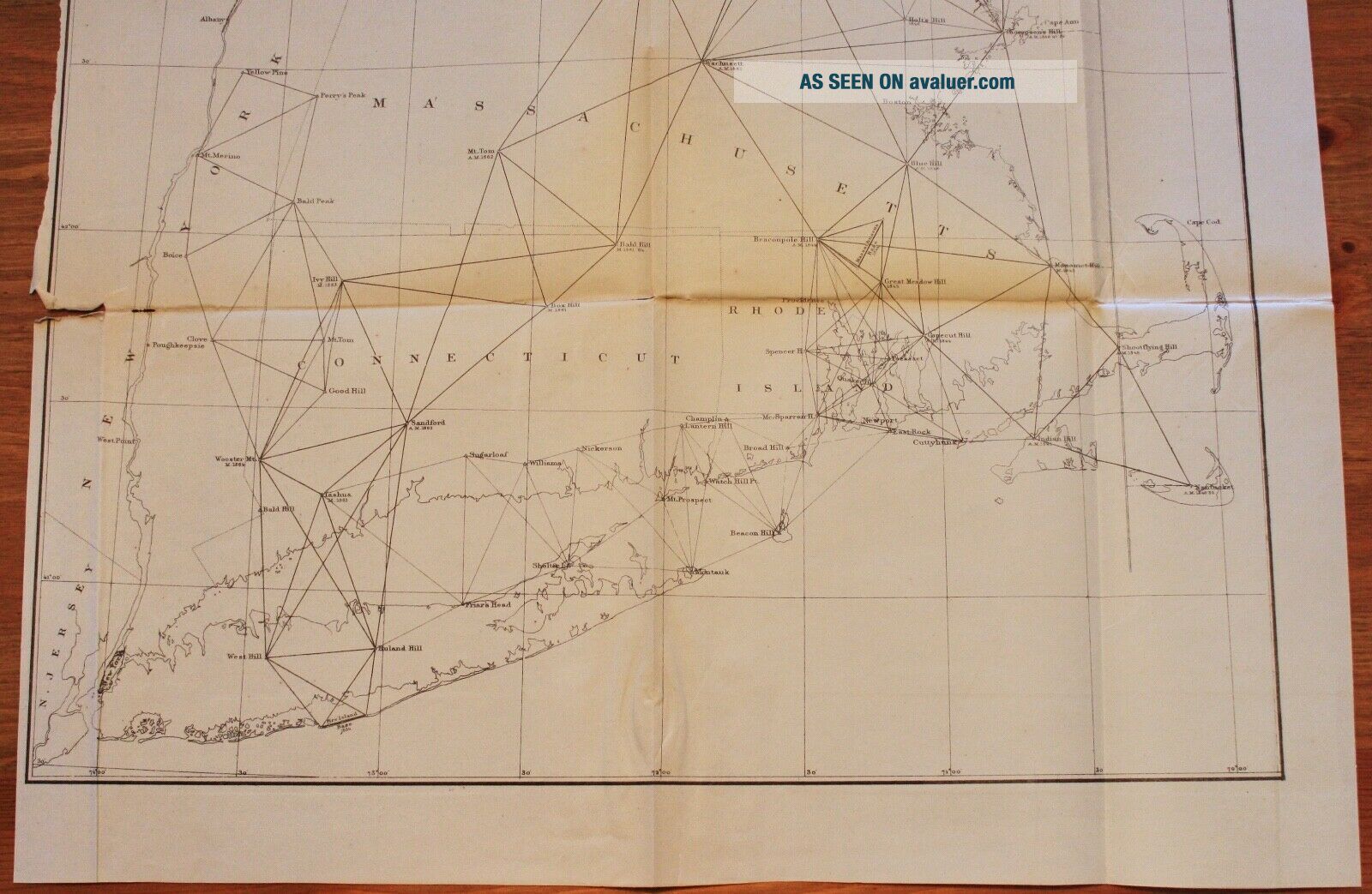
U.S. Coast Survey Sketch Illustrating the Nantucket Arc of Meridian and Adjustment of the Triangulation of Long Island SoundReport of 1868, Map 6Benjamin Peirce Superintendent

The map includes Notes & Tides.Map in fair condition with two tears and one hole.16" x 24-1/2"
Item #MCS-29
Shipping is standard post (no tracking) for Canada and US. Express, tracking, and international shipping by quote. If purchasing multiple items within 5 days, shipping will be combined for ...a discount and mailed together. If items aren't automatically combined for the discount, a refund will be issued upon mailing.


    Similar items


  • 1868 Us Coast Survey Map Of Chesapeake Bay,  Maryland,  Delaware

    1868 Us Coast Survey Map Of Chesapeake Bay, Maryland, Delaware

  • 1863 Us Coast Survey Map Florida Reefs Key Largo Long Island Matecumbe

    1863 Us Coast Survey Map Florida Reefs Key Largo Long Island Matecumbe

  • 1868 Us Coast Survey Chart Of The Straits Of Florida,  Key West,  Cuba

    1868 Us Coast Survey Chart Of The Straits Of Florida, Key West, Cuba

  • 1863 Us Coast Survey Map Atlantic Coast Nantucket To Cape Hatteras

    1863 Us Coast Survey Map Atlantic Coast Nantucket To Cape Hatteras

  • Atlantic Gulf Of Mexico And Pacific Coasts 1863 Us Coast Survey Map Chart

    Atlantic Gulf Of Mexico And Pacific Coasts 1863 Us Coast Survey Map Chart

  • Washington Sound And Approaches Washington Territory 1863 Us Coast Survey Map

    Washington Sound And Approaches Washington Territory 1863 Us Coast Survey Map

  • 1855 Us Coast Survey Map Delaware & Chesapeake Bays Inlets Lighthouses

    1855 Us Coast Survey Map Delaware & Chesapeake Bays Inlets Lighthouses

  • Preliminary Chart Of Half Moon Bay California 1863 Us Coast Survey Map Chart

    Preliminary Chart Of Half Moon Bay California 1863 Us Coast Survey Map Chart


    • You might also like


    • 1860 Mitchell Hand Colored Map Colorado,  Nebraska & Kansas - Civil War Era

      1860 Mitchell Hand Colored Map Colorado, Nebraska & Kansas - Civil War Era

    • 18th Century French Map Of North America

      18th Century French Map Of North America

    • Las Vegas Nevada Vintage 1967 Us Geological Survey Quadrangle Map 4 Panels

      Las Vegas Nevada Vintage 1967 Us Geological Survey Quadrangle Map 4 Panels

    • Rare Antique 1845 Maps United States Exploring Expedition Book Antartica Hawaii

      Rare Antique 1845 Maps United States Exploring Expedition Book Antartica Hawaii

    • Vintage 1926 Map Hollywood From The Best Surveys Of The Time

      Vintage 1926 Map Hollywood From The Best Surveys Of The Time

    • American Continent (western Hemisphere) 1747 Bowen Antique Copper Engraved Map

      American Continent (western Hemisphere) 1747 Bowen Antique Copper Engraved Map

    • Gulf Coast Florida Texas United States 1705 De Fer Unusual Antique Engraved Map

      Gulf Coast Florida Texas United States 1705 De Fer Unusual Antique Engraved Map

    • California As Island United States 1700 De Fer Unusual First Edition Antique Map

      California As Island United States 1700 De Fer Unusual First Edition Antique Map

Avaluer          About Us          Privacy Policy          Contact Us          UP
© 2022, avaluer.net, Inc. or its affiliates