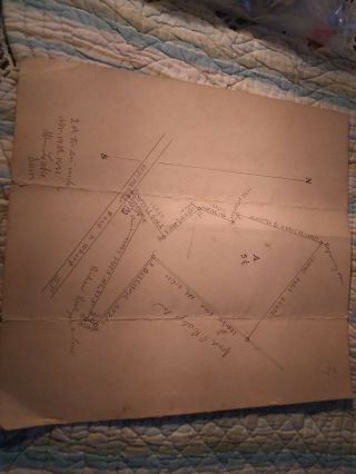
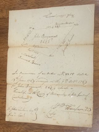
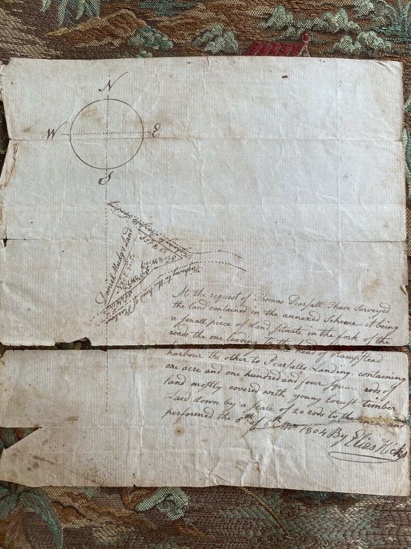
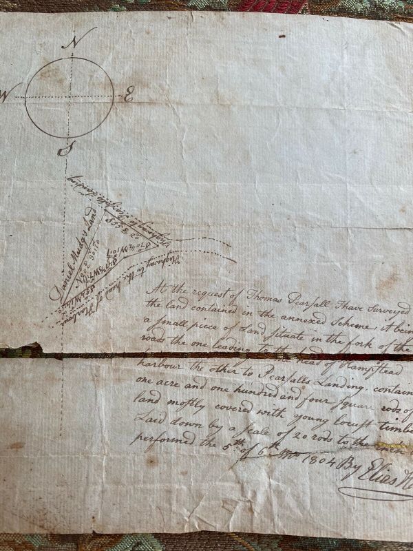
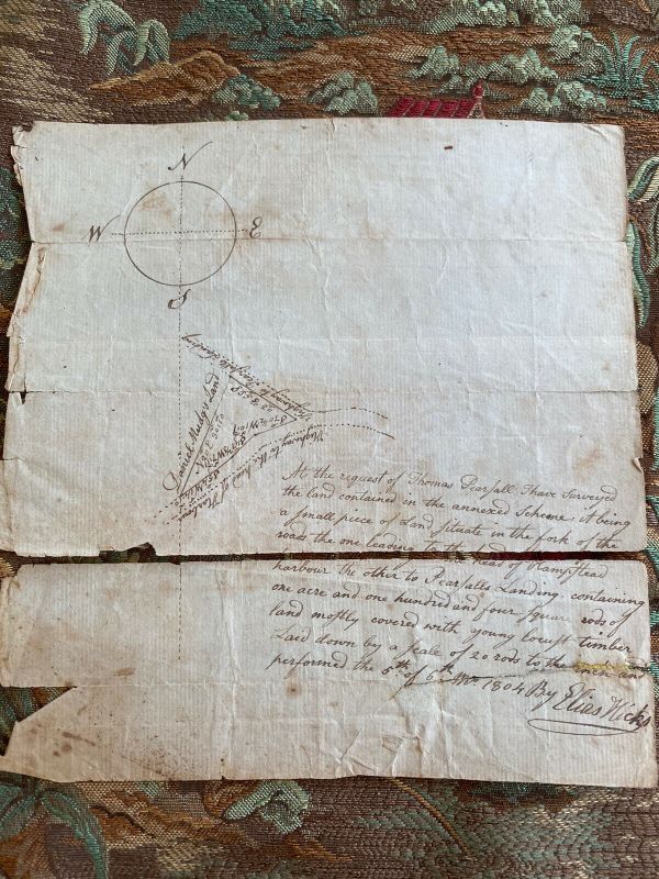
June 5, 1804 Survey Map By Elias Hicks For Land Near Hempstead, Long Island, NY


Item History & Price

Information:
Reference Number: Avaluer:54868606
Original Description:
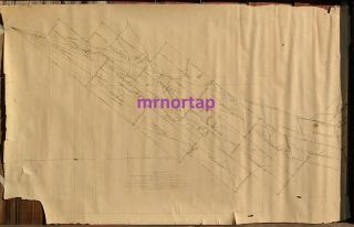
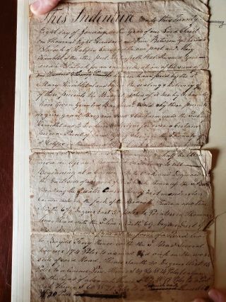
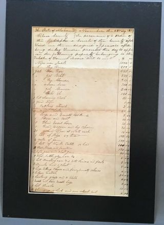
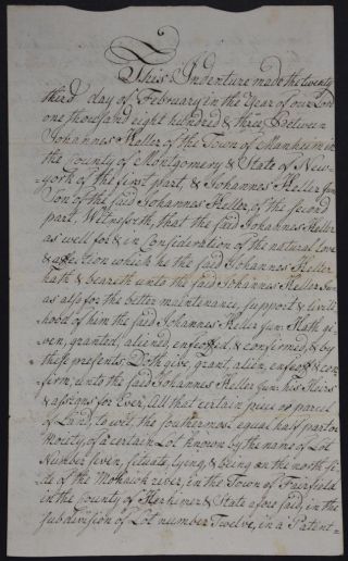
June 5, 1804 survey map by Elias Hicks for a small parcel of land, covered with locust trees, near the roads to Hempstead harbor and Pearsall’s Landing. This is a neat little piece of Long Island history that mentions the names of several prominent citizens of the area - Thomas Pearsall, Daniel Mudge (a quick Google search suggests that Mudge’s house is still standing) and Royal Aldrich (reverse side).This survey was found in the attic of a house on Long Island. Consistent with its... age, it’s in fragile condition and is in two pieces. One piece has been torn and taped. It also has tears, folds, stains, torn edges and creases. It will be packaged very carefully in a protective acrylic sleeve to prevent further damage.


    Similar items


  • 1921 Darwin Mining Claims Survey Map By Sherwin Inyo Co.  California

    1921 Darwin Mining Claims Survey Map By Sherwin Inyo Co. California

  • 5 Ordnance Survey Map Ta Brigg Beverley N Caistor Grimsby S Waltham Brandesburto

    5 Ordnance Survey Map Ta Brigg Beverley N Caistor Grimsby S Waltham Brandesburto

  • Official National Survey Maps By Lawton V.  Crocker

    Official National Survey Maps By Lawton V. Crocker

  • 0.  5 " Ordnance Survey Map 29 London St Albans 1914 Watford Harrow Hertford Dunmow

    0. 5 " Ordnance Survey Map 29 London St Albans 1914 Watford Harrow Hertford Dunmow

  • Tobago 1926 Survey Map By Capt.  G.  H.  Latham R.  E. ,  Printed By O.  S.

    Tobago 1926 Survey Map By Capt. G. H. Latham R. E. , Printed By O. S.

  • 1881 Survey Map By William Lake Pleasantville N.  J.  Basin Area

    1881 Survey Map By William Lake Pleasantville N. J. Basin Area

  • Bbc 1959 Civil War Battlefields.  C V Wedgwood.  5 Ordnance Survey Maps.  Pristine

    Bbc 1959 Civil War Battlefields. C V Wedgwood. 5 Ordnance Survey Maps. Pristine

  • 22 5 Ordnance Survey Map 25 " 1906 Clitters Plant

    22 5 Ordnance Survey Map 25 " 1906 Clitters Plant ' N Tolcarne Lemarnedown Mine


    • You might also like


    • 1881 Bill Of Lading Ship " Germanic " White Star Line - - Horrible

      1881 Bill Of Lading Ship " Germanic " White Star Line - - Horrible

    • 1769 Westmoreland Co Pa Land Tract Survey Map John Bargamot Property

      1769 Westmoreland Co Pa Land Tract Survey Map John Bargamot Property

    • Halifax County,  Va Revolutionary War Soldier Zachariah Blalock Signed Deed 1805

      Halifax County, Va Revolutionary War Soldier Zachariah Blalock Signed Deed 1805

    • 1839 Antique 19thc Ephemera Alabama Estate Appraisal Old Slave Receipt Letter

      1839 Antique 19thc Ephemera Alabama Estate Appraisal Old Slave Receipt Letter

    • 1856 - 1877 Receipt Book J W L Tylee Charleston Sc Csa Washington Artillery

      1856 - 1877 Receipt Book J W L Tylee Charleston Sc Csa Washington Artillery

    • 1854 - Providence Tool Company - 100 Antique Manuscript Orders

      1854 - Providence Tool Company - 100 Antique Manuscript Orders

    • Antique Labor Ledger Boy & Girls Mule Room Textile Workers 1847 - 48 Bedford

      Antique Labor Ledger Boy & Girls Mule Room Textile Workers 1847 - 48 Bedford

    • 1803 Herkimer York Document Land Deed Rev War Vets Kaufman Kelller Van Slyck

      1803 Herkimer York Document Land Deed Rev War Vets Kaufman Kelller Van Slyck

Avaluer          About Us          Privacy Policy          Contact Us          UP
© 2022, avaluer.net, Inc. or its affiliates